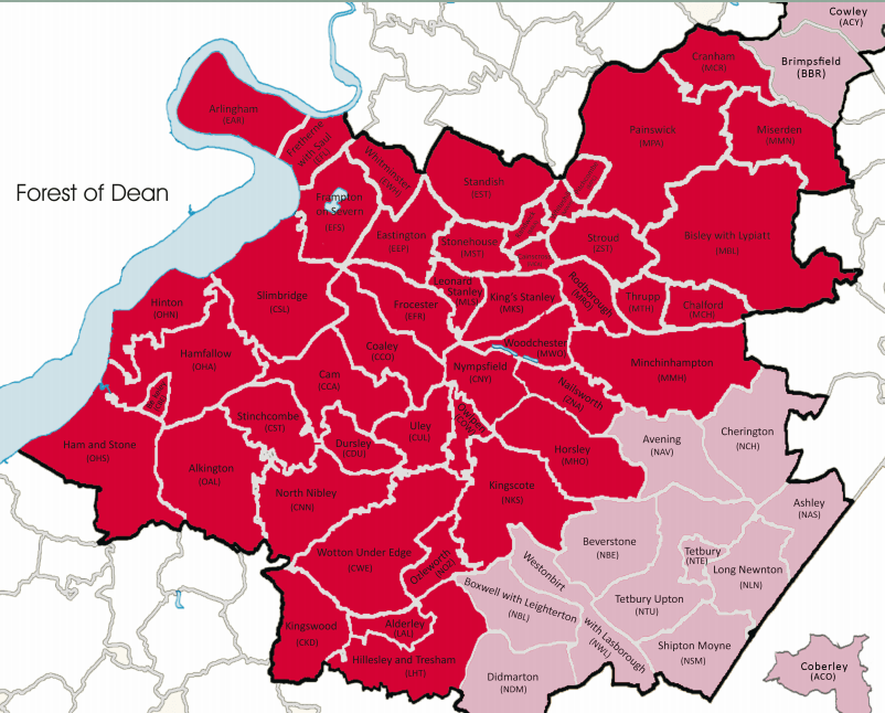
Our Parishes
As the South Cotswolds covers a large area with 60 parishes, volunteers are always most welcome, perhaps as a Parish Path Checker (see below), or to investigate problems.
Study a copy of the Gloucestershire Definitive Map here
Please send us a message on the Contact Us form if you have any questions or comments.
Please Contact Us if you would like to check Public Rights of Way in one of our 60 parishes.
Thank you
| Alderley (trinome = LAL) | ||
| Alkington (OAL) | ||
| Arlingham (EAR) | ||
| Ashley (NAS) | ||
| Avening (NAV) | ||
| Berkeley (CBE) | ||
| Beverston (NBE) | ||
| Bisley with Lypiatt (MBL) | ||
| Boxwell with Leighterton (NBL) | ||
| Brimpsfield (BBR) | ||
| Brimscombe and Thrupp (MTH) | ||
| Cainscross (MCA) | ||
| Cam (CCA) | ||
| Chalford (MCH) | ||
| Cherington (NCH) | ||
| Coaley (CCO) | ||
| Coberley (ACO) | ||
| Cowley (ACY) | ||
| Cranham (MCR) | ||
| Didmarton (NDM) |
| Dursley (CDU) | ||
| Eastington (EEA) | ||
| Frampton-on-Severn (EFS) | ||
| Fretherne with Saul (EFL) | ||
| Frocester (EFR) | ||
| Ham and Stone (OHS) | ||
| Hamfallow (OHA) | ||
| Hillesley and Tresham (LHT) | ||
| Hinton (OHN) | ||
| Horsley (MHO) | ||
| King's Stanley (MKS) | ||
| Kingscote (NKS) | ||
| Kingswood (CKD) | ||
| Leonard Stanley (MLS) | ||
| Long Newnton (NLN) | ||
| Minchinhampton (MMH) | ||
| Miserden (MMN) | ||
| Nailsworth (ZNA) | ||
| North Nibley (CNN) | ||
| Nympsfield (CNY) |
| Owlpen (COW) | ||
| Ozleworth (NOZ) | ||
| Painswick (MPA) | ||
| Pitchcombe (MPC) | ||
| Randwick (MRA) | ||
| Rodborough (MRO) | ||
| Shipton Moyne (NSM) | ||
| Slimbridge (CSL) | ||
| Standish (EST) | ||
| Stinchcombe (CST) | ||
| Stonehouse (MST) | ||
| Stroud (ZST) | ||
| Tetbury (NTE) | ||
| Tetbury Upton (NTU) | ||
| Uley (CUL) | ||
| Westonbirt with Lasborough (NWL) | ||
| Whiteshill and Ruscombe (MWH) | ||
| Whitminster (EWH) | ||
| Woodchester (MWO) | ||
| Wotton-unde-Edge (CWE) |


